Barrier Station
From Dogcraft Wiki
(new) Tags: Removed redirect Visual edit |
mNo edit summary Tag: Visual edit |
||
| Line 5: | Line 5: | ||
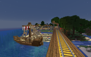
Barrier Station lies on the coast by a small natural harbor with a coral reef visible offshore from which it takes its name. It is formed of a central square with low open-sided buildings housing the platforms arranged around it. A sailing ship moored at the jetty provides the required phantom shelter while a lighthouse on the other side of the bay guides passing ships to port. | Barrier Station lies on the coast by a small natural harbor with a coral reef visible offshore from which it takes its name. It is formed of a central square with low open-sided buildings housing the platforms arranged around it. A sailing ship moored at the jetty provides the required phantom shelter while a lighthouse on the other side of the bay guides passing ships to port. | ||
== South Line Stations == | ==South Line Stations== | ||
* [[Grand Central Station (Survival 3)|Grand Central Station]] | *[[Grand Central Station (Survival 3)|Grand Central Station]] | ||
* [[South Station (Survival 3)|South Station]] | *[[South Station (Survival 3)|South Station]] | ||
* [[Coconut Station]] | *[[Coconut Station]] | ||
* [[Snowman Station]] | *[[Snowman Station]] | ||
* '''Barrier Station''' ''- you are here'' | *'''Barrier Station''' ''- you are here'' | ||
* Neon Station | *[[Neon Station]] | ||
* Tower Station | *[[Tower Station]] | ||
* Luxor Station | *[[Luxor Station]] | ||
== Branch Lines == | ==Branch Lines== | ||
* ''None'' | *''None'' | ||
{{Navbox Survival 3}} | {{Navbox Survival 3}} | ||
Revision as of 03:38, 28 March 2020
| Barrier Station | |
|---|---|
| Survival 3 | |
| Station | |
| World | Survival 3 |
| Network | Survival Railway Network (Survival 3) |
| Line | South Line |
| Opened | 6th September, 2019 |
| Builder(s) |  Mrs_Diss Mrs_Diss |
| Connections | |
Barrier Station is the fourth stop on the South Line after leaving Snowman Station.
Barrier Station lies on the coast by a small natural harbor with a coral reef visible offshore from which it takes its name. It is formed of a central square with low open-sided buildings housing the platforms arranged around it. A sailing ship moored at the jetty provides the required phantom shelter while a lighthouse on the other side of the bay guides passing ships to port.
South Line Stations
- Grand Central Station
- South Station
- Coconut Station
- Snowman Station
- Barrier Station - you are here
- Neon Station
- Tower Station
- Luxor Station
Branch Lines
- None
 Survival 3
World Outline Settlements The Home Tree · Chronia (Country Club) · Barkenstein · Ouranos (Metro) · Dragon Valley (Lore) · Calafort · Raid Point · Erebus · Aeon City · Cake TownProjects Bases Events
This page was last modified on 28 March 2020, at 03:38. (2 years ago)

